I covered my trip northward through the Salinas Valley in Part II. In this last segment of California Dreamin' I'll cover it again, only with a few photos and some additional details.
In Part VII, I had just pulled into Paso Robles on a Wednesday night after traversing up and over the Parkfield Grade. I had one more medical office building to look at in Templeton for a mold assessment, part of my whirl-wind week-long tour of California with sites in San Leandro, Los Gatos, and Manteca. Templeton lies between Paso Robles and Atascadero. I was booked into a Hampton Inn on the southern edge of Paso Robles for Wednesday and Thursday nights. It was a brand new hotel catering to the Central Coast wine tour crowd. With that theme in mind, I picked up a bottle of Castoro Cellars Fume Blanc from the local supermarket along with some other food items to stock in my room's pony fridge.
I met my site contact Thursday morning and went through the small building of medical office suites, mostly vacant. The site contact obviously had more important responsibilities, being the facilities manager at the local hospital, but he was polite and made sure I saw everything I needed. He was a younger good old boy who grew up in Bakersfield, a chunk of Oklahoma dropped into the center of California. He had a real nice rig, a Toyota Tundra in bright metallic blue, lifted and tricked out, and too nice to thrash off road. I was the only consultant (among several disciplines on this project) who had called ahead and scheduled an appointment for a site visit so he gave me some credit for that. My years of doing these things have taught me to head Murphy off wherever you can and confirming site visits is plain old Consulting 101. It surprises me to hear about consultants who just show up expecting to walk through. I couldn't afford any schedule glitches on this week-long tour.
I wrapped up the site visit in about an hour. I supposed I could've made a flight out of Oakland later that day. But the San Leandro draft report was due the following day (Friday) and I would've have lost a precious day driving up to Oakland. I sequestered myself in my room the rest of the day and into the night working on the San Leandro report. I finished it and emailed it off that night.
I didn't get to see much of Paso Robles except for driving around looking for places to eat and buy a latte at anyplace but Starbucks. I vaguely remember Paso Robles from passing through there on family vacations on the way up to Oregon for camping. We stayed in a motel there once. I had a shoebox full of wooly bear caterpillars that my mother allowed me to bring along on the trip or else they would starve. As a kid I always had some captured creatures I would keep like caterpillars, spiders including black widows, and lizards. Caterpillars were most fun because they eventually pupated and emerged as moths or butterflies. As it turned out, the shoebox of caterpillars was left behind outside of the motel room. When I realized we had forgotten the caterpillars we were already well down the road. I think my parents were secretly relieved of having to deal with a box full of caterpillars through a whole family camping trip.
I left Paso Robles Friday morning heading north through the Salinas Valley to catch a flight out of Oakland back to Seattle. I made several stops along the way as I mentioned in Part II.
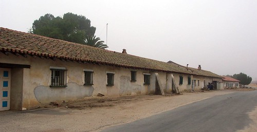
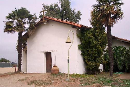
My first stop was Mission San Miguel Arcangel. Early morning low clouds added grayness and mystery to the mission buildings. The history of the mission includes the tragic murders of the Reed family here in 1848. I walked all around the perimeter of the mission, the gift shop and museum not opening until later in the morning. The church was closed indefinately, undergoing repairs from a December 2003 earthquake. The cracks in the front church wall are readily obvious. The repair operations are much in evidence around the church and associated buildings.
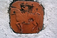
Across from Mission San Miguel is the Rios-Caledonia Adobe. I was the only there this morning except for the still slumbering caretaker. I feely walked the grounds without another soul to disturb my thoughts.
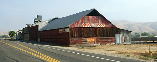
I stopped to photograph an old feed mill in San Miguel. It reminded me of the old CC Stafford feed mill near where I grew up as a boy, the mill already in decay as suburbia grew around it.
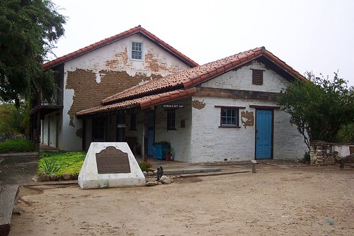
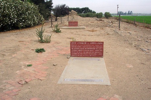
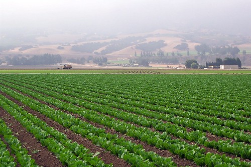
My last stop was at Mission Nuestra Senora de la Soledad. The mission sits out in the middle of the Salinas valley lettuce fields, isolated, with no adjacent town or city. I pretty much had the run of the place being the only tourist present. From my readings I recognized one of two marked graves as that of Jose Joaquin de Arrillaga.
"As soon as we were informed of the arrival of the gobernador [Arrillaga], Lieutenant Davidov was sent ashore to welcome the company and extend our warmest acknowledgements for the friendly manner in which we had been received. On the following morning, when we expected our visit to be returned, there came two religiosos tendering apologies of the gobernador that, being advanced in years and of feeble constitution, he hoped to be excused from returning the visit, and at the same time requesting Rezanov, with all of the officers, to visit him at the presidio. The invitation was accepted, and we all went to the presidio, where we became acquainted with the gobernador, a venerable looking man of sixty years. He had come a distance of no less than twenty-five German miles, solely for the purpose of showing respect to us and making our stay as agreeable as possible."
Georg von Langsdorff - 1806
John Steinbeck describes the essence of California and the Salinas Valley the best in the opening of East of Eden.
"The Salinas Valley is in Northern California. It is a long narrow swale between two ranges of mountains, and the Salinas River winds and twists up the center until it falls at last into Monterey Bay.
I remember my childhood names for grasses and secret flowers. I remember where a toad may live and what time the birds awaken in summer - and what trees and seasons smelled like - how people looked and walked and smelled even. The memory of odors is very rich.
I remember that the Gabilan Mountains to the east of the valley were light gay mountains full of sun and loveliness and a kind of invitation, so that you wanted to climb into their warm foothills almost as you want to climb into the lap of a beloved mother. They were beckoning mountains with a brown grass love. The Santa Lucias stood up against the sky to the west and kept the valley from the open sea, and they were dark and brooding - unfriendly and dangerous. I always found in myself a dread of west and love of east. Where I ever got such an idea I cannot say, unless it could be that the morning came over the peaks of the Gabilans and the night drifted back from the ridges of the Santa Lucias. It may be that the birth and death of the day had some part in my feeling about the two ranges of mountains."
John Steinbeck - East of Eden

2 comments:
Hey I found whis blog while searching for info on the CC Stafford feed mill in La Puente. I lived in La Puente as a boy between 1966-1972 and that old building was pretty spooky looking at night.
I lived in La Puente from 1958 to 1966 when we moved 'up the hill' to Hacienda Heights ('the Heights'). I attended Willow Elementary. All my friends were Hispanic, it was a pretty well integrated neighborhood then. I remember the Stafford mill well, every time we drove by it on Hacienda Blvd crossing the tracks. That whole strip between Nelson and the train tracks we called the cow pens, because that's what they used to be. I'm sure you remember Leo Hoffman Chevrolet. It was a great area to grow up in at that time, especially when we moved up to the Heights where there was still a lot of open space and hills for boys to roam around. One of the saddest days was when they turned San Jose Creek into a concrete ditch. I guess they felt like they had to after the creek flooded in 1969 and took out the Anaheim-Puente Road bridge (now Azusa Road). Much has changed.
Post a Comment